


Maps of The Villages Florida
(2026 Guide to Neighborhoods, Squares & Areas)
The map of The Villages, Florida looks simple… right up until you try to figure out where anything actually is.
Between the winding roads, expanding neighborhoods, multiple town squares, and golf courses layered into everything, it can feel less like a town and more like a very well-organized maze. This guide breaks it all down in a way that actually makes sense.
Key Takeaways:
The Villages spans about 57 square miles across three counties. To navigate it, think in zones: north of 466 is older/established, between 466 and 466A is central, and south of 466A is the newest growth.
Two main roads — Buena Vista/Morse Blvd (north-south) and 466/466A (east-west) — are your main reference points, with 80+ named neighborhoods grouped into larger Districts around them.
Finding The Villages on a Large Map
Florida is a long State-- but you can find The Villages easily on a large map.
To locate The Villages, look along the Gulf and find the deepest indentation.
The Villages is due East of the middle of that indentation, and pretty much in the middle of the State.
That can come in handy for weather developments or anything about Florida when you think.... is that close to The Villages?

How to Understand the Maps of The Villages, Florida

The Villages is not a traditional town with a clear center or a simple grid. Instead, it stretches north to south and has been developed in phases over time. Think of it less like one town and more like a collection of connected communities.
That’s also why it seems that there is no single map that tells the whole story. Some maps focus on Town Squares, others on golf courses or recreation centers, some on crime areas, and others on shopping and dining areas. Oh, and don't forget, The Villages is being added to constantly. .
The goal is not to memorize any map—it’s to understand how it’s organized. Once you do that, navigating The Villages becomes much more natural.
North-South Navigation in
The Villages
Main North-South Roads (Your Anchors)
Buena Vista and Morse Blvd run north to south and connect most of The Villages.
The Villages Town Squares Map
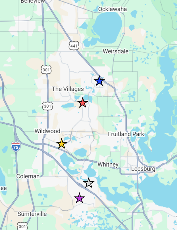
"Find the Squares on a Map" Tricks....
If you are looking at a large map, first, look for the Lakes in the middle of The Villages called The Great Lakes of The Villages.
Ok, that's not true, I just made that up.
But, its a good way to find Lake Sumter Square-- just south of those lakes in the middle. (Lake Sumter). Spanish Springs and Brownwood make a straight line, (roughly 1:00 -7:00) inside and next to the Highways/State Roads.
For Sawgrass and Eastport: if you look closely-- the Turnpike gets wider. The two squares are on either side of that wider area.
Here's more information about The Squares Here.
Spanish Springs
Lake Sumter
Brownwood
Sawgrass Grove
Eastport
The Villages Florida District Maps
One of the most unique parts of The Villages is how neighborhoods are named and organized. Instead of traditional subdivisions, you will see names like “Village of ___,” each representing a specific residential area, and they are in Districts.
There are over 80 distinct Villages. There are often grouped around recreation centers and golf courses, which means each area has its own feel and level of activity. Some are quieter and more tucked away, while others are closer to town squares and busier social areas.
When people talk about where they live, they are usually referring to their specific village rather than a larger district, which can take some getting used to at first. A map for districts
Map of The Villages:
A Quick Cheat Sheet
Main East West Roads-- 466 and 466A
Not very imaginative naming, but it works.
The “Zones”
-
North of 466 → earlier neighborhoods
-
Between 466 & 466A → central area
-
South of 466A → newer development
466 & 466A , Shopping, Dining,
and Convenience Areas on the Map
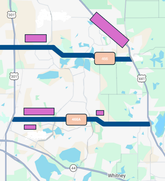
-- Retail Corridors
While the town squares get a lot of attention, much of everyday life happens along the main commercial corridors.
The areas around County Road 466 and 466A, and areas along 441 are packed with grocery stores, restaurants, medical offices, and retail centers. These are the places residents rely on for day-to-day needs. There are also smaller clusters of shops and services throughout the community, often located near major intersections or just outside residential areas.
Once you identify these corridors on the map, it becomes much easier to understand where to go for what you need. Although there are smaller areas, and ones that are being built all the time, this map will show you the main ones.
Golf Courses Map
If you’re trying to figure out where the nearest golf course is, you might expect to find a dedicated golf map right away. In reality, the official version is tucked inside the districts section of their site. Once you know where to look, it’s easy enough—but it’s not exactly where most people think to check first.
If you want to explore the official map, you can find it at the bottom of the page on their Districts Page here. You can get more information about the Golf Life of The Villages Here.